
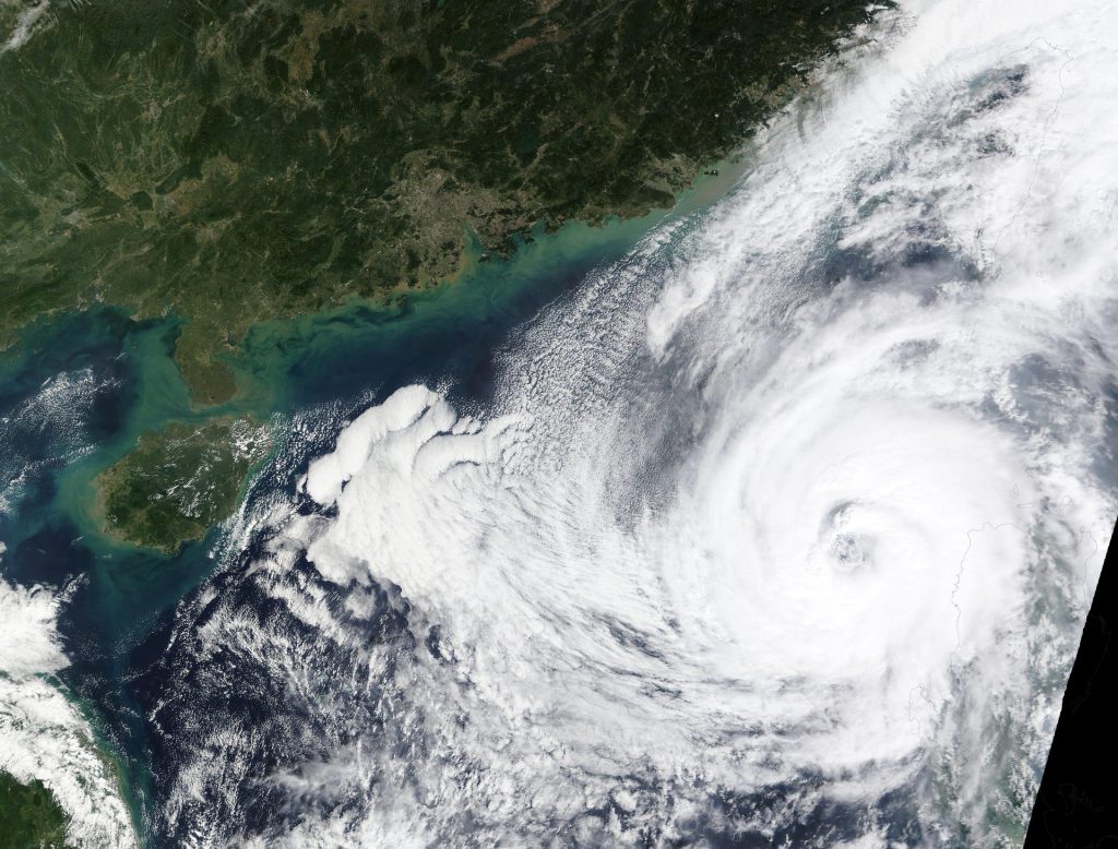
Typhoon Cempaka Strengthens to 120 km/h as It Nears the Philippines — But It Will Not Make Landfall
Typhoon Cempaka has grown stronger over the Philippine Sea and is heading towards the Philippines — but the good news is that it is not expected to hit land. The storm is forecast to briefly enter the Philippine Area of Responsibility on Monday morning, 9 November, when it will be given the local name Samuel, before turning away and heading back out to sea.
The Philippines’ state weather bureau, PAGASA, said on Sunday, 8 November, that Cempaka had intensified into a typhoon. It is the latest storm in a busy year for the country, which sits in one of the most typhoon-prone parts of the world. Here is what we know so far, what the storm will do next, and why forecasters are calm about this one.
What happened
Cempaka spent the weekend gathering strength over the open waters of the western Pacific, far to the east of the Philippines. PAGASA issued its first advisory on the storm late on Saturday, 7 November, when it was still a severe tropical storm.
By Sunday morning, the storm was holding its strength. At 10 a.m. on Sunday, its centre was about 1,720 kilometres east of extreme Northern Luzon, with maximum sustained winds of 110 kilometres per hour near the centre and gusts of up to 135 kilometres per hour. Its central pressure was 990 hectopascals.
Then, during Sunday afternoon, Cempaka crossed the line from a severe tropical storm into a typhoon. In its 5 p.m. advisory, PAGASA said the storm’s maximum sustained winds had risen to 120 kilometres per hour, with gusts of up to 150 kilometres per hour, and its central pressure had fallen to 980 hectopascals. Falling pressure and rising winds are the classic signs of a strengthening tropical cyclone.
At 4 p.m. on Sunday, the centre of the typhoon was estimated at about 1,600 kilometres east of extreme Northern Luzon, moving west-northwest at 20 kilometres per hour. That is roughly the speed of a cyclist in a city — slow enough for forecasters to track it closely, but fast enough to cover hundreds of kilometres in a day.
Where is Typhoon Cempaka heading?
The short answer is: towards the Philippines, but only just — and then away again.
PAGASA forecasts that Cempaka will keep moving west-northwest until it enters the Philippine Area of Responsibility, known as PAR, on Monday morning, 9 November. The moment it crosses into that area, it will be given its local name: Samuel.
But its stay inside Philippine-monitored waters will be brief. The storm is expected to turn north-northeastward on Monday afternoon or evening, and to leave the PAR through its northeastern boundary by Monday evening or early on Tuesday, 10 November.
In other words, Cempaka will clip the edge of the Philippines’ area of responsibility rather than ploughing through it. It will remain over the Philippine Sea for the whole of its forecast track, far from land, and it is not expected to make landfall anywhere in the Philippines.
PAGASA expects the typhoon to keep strengthening before it weakens. Its forecast shows winds rising to around 140 kilometres per hour by Monday morning, and possibly reaching 150 to 155 kilometres per hour by early Tuesday, before a gradual weakening begins.
No wind signals have been raised over any part of the Philippines, and PAGASA has said the storm “will not directly affect weather or sea conditions” across the country. Its next advisory was scheduled for 11 p.m. on Sunday.
Why it will not hit the Philippines
Typhoons are steered by the winds around them, much like a leaf is carried by a stream. Cempaka is being pushed west-northwest by the winds on the edge of a high-pressure system, but forecasters expect that steering flow to change on Monday, bending the storm’s path towards the north and then the northeast — away from the Philippines and out over the open Pacific.
This kind of near-miss is common. Many tropical cyclones form far out in the Pacific and pass close to the Philippines without ever touching land. What matters is the exact shape of the steering winds, which is why PAGASA issues fresh advisories every six hours and updates its track forecast each time.
The storm’s distance is also on the Philippines’ side. At 1,600 kilometres away, Cempaka is roughly as far from Luzon as London is from Rome. Even at its closest approach, it is expected to stay well out at sea.
What it means for the Philippines
Even though Cempaka will not make landfall, people in the northern Philippines should still pay attention to the sea.
PAGASA has warned that moderate to rough seas are expected over the seaboards of Northern and Central Luzon within the next 24 hours, and that very rough seas may affect the seaboards of Northern Luzon from Tuesday, 10 November, onwards. A gale warning will likely be issued on Monday. On Monday, waves of 1.5 to 3.4 metres are expected along the northern and eastern coasts of Luzon. Small boats and fishing vessels should stay alert and follow the advice of local officials.
The weather over land on Monday will be shaped by two other systems, not by Cempaka. The northeast monsoon, known locally as Amihan, and the easterlies — warm winds blowing in from the Pacific — are forecast to bring cloudy skies with scattered rain and thunderstorms to the Bicol Region, Eastern Visayas, Caraga, Quezon and Davao Oriental.
In short: rain in parts of the country on Monday, rough seas off the northern coasts, but no typhoon landfall and no storm signals.
Why does the storm have two names?
If you have been following the news, you may have noticed the storm being called both Cempaka and Samuel. That is not a mistake — it is how storm naming works in this part of the world.
Cempaka is the storm’s international name. Tropical cyclones in the western North Pacific are named from a list shared by 14 countries and territories, coordinated by the Japan Meteorological Agency. Each country contributes names, and they are used in order as storms form.
Cempaka was contributed by Malaysia. It is the name of a plant known for its fragrant flowers — the champak, or Magnolia champaca. The name replaced Melor on the list after 2015, and it was last used for a typhoon in 2021, a long-lived storm that caused substantial damage in China and Vietnam.
Samuel is the storm’s local name. When a tropical cyclone enters the Philippine Area of Responsibility, PAGASA gives it a name from its own list, so that Filipinos can follow it easily in local news and warnings. The two names describe the same storm — Cempaka is what the rest of the world calls it, and Samuel is what it will be called inside the Philippines.
Why the Philippines sees so many typhoons
The Philippines is one of the most typhoon-prone countries on Earth. On average, around 20 tropical cyclones form within or enter the Philippine Area of Responsibility each year, and about eight or nine of them cross the country’s land, according to PAGASA. Around 70 percent of them develop during the peak season, from July to October — so a November storm like Cempaka arrives near the tail end of the season.
There are two reasons for this. First, the Philippines sits in the western Pacific, where the ocean is warm enough — usually above 26.5 degrees Celsius — to feed tropical cyclones for much of the year. Second, the country’s eastern seaboard faces the open Pacific, so storms forming over the warm water to the east often meet the Philippines before any other land.
By early September this year, the country had already recorded 16 tropical cyclones in 2026, according to PAGASA figures reported at the time. Cempaka is one of the late-season arrivals, and its path — curving away to the northeast — is a familiar one for storms that form late in the year. Typhoons do not always fade quietly, either: Findivoza recently reported on how the remnants of ex-Typhoon Champi brought a run of storms to Alaska.
The experience also explains why the Philippines has one of the most practised warning systems in the world. PAGASA’s network of advisories, wind signals and local names is designed so that people get clear, early information — and so that a storm that will miss the country, like Cempaka, does not cause unnecessary alarm.
How a tropical storm becomes a typhoon
A tropical cyclone is a giant spinning system of clouds and thunderstorms that forms over warm ocean water. It grows in stages, and each stage has a name.
It starts as a low-pressure area, a patch of unsettled weather. If the sea is warm and the winds above are favourable, it can organise into a tropical depression, with winds of up to 62 kilometres per hour. If it strengthens further, it becomes a tropical storm, with winds from 63 to 88 kilometres per hour, and it earns a name. A severe tropical storm has winds from 89 to 117 kilometres per hour. Once sustained winds pass 118 kilometres per hour, it is a typhoon.
Cempaka crossed that line on Sunday afternoon, when its winds reached 120 kilometres per hour. If its winds climb towards 150 or 155 kilometres per hour as forecast, it will be a strong typhoon — but still far below the most destructive storms, whose winds can exceed 220 kilometres per hour.
The scale of these storms is hard to picture. A mature typhoon can be hundreds of kilometres wide, carry more energy than many power stations, and drop enormous amounts of rain. That is why even a storm that stays at sea can matter: its outer winds can whip up dangerous seas hundreds of kilometres from its centre.
What to watch next
Forecasters will be watching three things over the next two days.
First, the exact moment Cempaka enters the PAR on Monday morning, when it officially becomes Samuel in Philippine bulletins. Second, whether the turn to the north-northeast happens on schedule on Monday afternoon — if the turn comes late, the storm would pass closer to land than expected. And third, whether it reaches its forecast peak of 150 to 155 kilometres per hour early on Tuesday, before weakening.
For most people in the Philippines, the practical advice is simple: this storm is not a threat to land, but the seas off Northern Luzon will be rough, and the usual November pattern of monsoon and easterly rain will continue. Fishermen and small boat operators should check PAGASA’s gale warnings before heading out, and everyone else can follow the storm’s progress in the regular advisories.
It is a useful reminder of how typhoon forecasting works. Not every storm that heads towards the Philippines hits it — and knowing which ones will turn away, and when, is just as important as warning about the ones that do not. For the latest information, PAGASA’s advisories remain the official source, and they are updated every six hours while a storm is active.
Frequently asked questions
What is Typhoon Cempaka?
Cempaka is a typhoon over the Philippine Sea, east of the Philippines. It intensified into a typhoon on Sunday, 8 November 2026, with maximum sustained winds of 120 kilometres per hour and gusts of up to 150 kilometres per hour.
Will Typhoon Cempaka hit the Philippines?
No. PAGASA forecasts that the storm will briefly enter the Philippine Area of Responsibility on Monday morning, 9 November, then turn north-northeast and leave by Monday evening or early Tuesday. It is not expected to make landfall or directly affect the country’s weather.
Why will it also be called Samuel?
Samuel is the local name PAGASA gives the storm once it enters the Philippine Area of Responsibility. Cempaka is its international name, contributed by Malaysia, meaning a plant known for its fragrant flowers.
How strong will Cempaka get?
PAGASA expects it to keep strengthening, with winds possibly reaching 150 to 155 kilometres per hour by early Tuesday, 10 November, before gradually weakening.
Is it safe to go fishing in Northern Luzon?
PAGASA has warned of moderate to rough seas over the seaboards of Northern and Central Luzon, with very rough seas possible off Northern Luzon from Tuesday. A gale warning is likely on Monday. Check the latest PAGASA advisory before heading out to sea.
Conclusion
Typhoon Cempaka is a powerful storm that is heading towards the Philippines but will not reach it. After strengthening to 120 kilometres per hour on Sunday, it is expected to enter the Philippine Area of Responsibility as Samuel on Monday morning, then curve away to the northeast and out to sea. No wind signals are in force, no landfall is expected, and the main impact will be rough seas off Northern Luzon.
It is the kind of storm that shows the value of careful forecasting: a typhoon that looks threatening on a map, but whose path keeps it safely offshore. It also arrives as the COP31 climate summit opens in Antalya, where support for developing countries facing extreme weather is on the agenda — the EU recently reported €41.6 billion in climate finance for developing countries, while saying there would be no new pledges at COP31. For the Philippines, which faces around 20 tropical cyclones a year, telling the difference between a near-miss and a direct hit is a skill that saves lives — and this time, the news is good.
Sources
- GMA News: https://www.gmanetwork.com/news/weather/content/1008739/cempaka-intensifies-into-typhoon-to-enter-par-on-monday-says-pagasa/story/
- Philstar: https://www.philstar.com/headlines/weather/2026/11/08/2568769/cempaka-expected-intensify-typhoon-entering-par
- Manila Times: https://www.manilatimes.net/2026/11/08/news/cempaka-intensifies-into-typhoon/2464716
- Manila Standard: https://manilastandard.net/news/weather/314815758/pagasa-sees-brief-entry-of-tropical-cyclone-cempaka.html
- GMA News: https://www.gmanetwork.com/news/weather/content/1008734/amihan-easterlies-to-drench-parts-of-luzon-davao-oriental/story/?amp
- Manila Bulletin: https://mb.com.ph/2026/09/01/2-to-3-tropical-cyclones-may-develop-in-september-pagasa
- Japan Meteorological Agency: https://www.jma.go.jp/jma/jma-eng/jma-center/rsmc-hp-pub-eg/tyname.html
- Wikipedia: https://en.wikipedia.org/wiki/List_of_storms_named_Cempaka
This article is for general information and education only. It is not legal or financial advice.
