
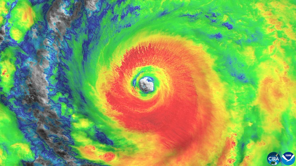
Typhoons Batter East Asia as El Niño Makes the Pacific ‘Burn With Fever’
For months, one powerful storm after another has battered East Asia. The scale of the disruption has gone far beyond a normal typhoon season. Dozens of people have been killed, major airports have closed, crops have been wiped out, and roads, power lines and homes have been damaged across a wide stretch of the region.
The cause is a natural climate pattern called El Niño. It has heated the Pacific Ocean to record levels, and the storms it is feeding are stronger, stranger and harder to predict than usual. Scientists warn the worst may not be over yet.
This is what has happened so far, why this season is different, and what could come next.
A season like no other
Wild weather is a familiar part of life for people living along the coasts of the Philippines, Taiwan, China and Japan. Typhoons arrive every year. But the last few months have been extraordinary.
In June, Japan watched two storms — Typhoon Mekkhala and Severe Tropical Storm Higos — race towards its eastern coast at the same time. One million people were told to evacuate.
In July, Tropical Storm Narra grazed China’s southern coast along Guangxi, submerging villages and displacing tens of thousands of people.
August brought Super Typhoon Dolphin, which churned across the Pacific for 16 days before slamming into eastern China, triggering heavy floods and dozens of casualties. Later that same month, Typhoon Saudel made landfall in three south-eastern Chinese cities over the course of a single week, shutting transport networks and forcing thousands more to evacuate. The sequence left little time for recovery between one storm and the next.
August also produced a storm that puzzled forecasters. Typhoon Chan-Hom crossed Japan from east to west — the opposite of the usual south-to-north path. Japan’s well-resourced and prepared authorities were able to evacuate people swiftly, but the same feat would be far more challenging in some neighbouring countries, where resources and warning systems are thinner.
Then came October, and the biggest storm of the season so far.
Typhoon Champi: a storm big enough to swallow Taiwan
In October, nearly all of Taiwan shut down as a vast storm bore down on its north-eastern coast. Typhoon Champi was large enough to engulf the island of 23 million people, and its winds of 295 kilometres per hour (193 miles per hour) put it on a par with a category five hurricane — the strongest class of tropical storm.
In the end, Champi did not make landfall in Taiwan. It skirted past the island while drenching it in rain. But a storm that never struck Taiwan directly still managed to disrupt travel, transport and daily life in several countries at once.
Hundreds of flights were cancelled in Hong Kong, Taiwan and Japan. In the Philippines’ Batanes archipelago, seaside highways shut as huge waves crashed onto the shore. In southern Japan’s Okinawa islands, power was cut to 15,000 homes.
Champi was the clearest warning yet of what a warmer Pacific can do. And forecasters say the danger is not passing.
What is El Niño, and why does it make typhoons stronger?
El Niño is a naturally occurring climate pattern. Warm waters pool in the eastern Pacific, and wind patterns change. Together, they drive extreme weather around the world.
It happens roughly every two to seven years and typically lasts for about a year. This year’s event, which the UK Met Office has forecast to be the strongest in living memory, is likely to last until February or March.
Warm water is fuel for a typhoon. A storm draws its energy from the heat of the ocean surface, so the warmer the water, the more powerful the storm can become.
That is exactly what is happening now. Last month, sea surface temperatures in the equatorial Pacific — the area monitored by the Japan Meteorological Agency for its El Niño predictions — soared to four degrees above normal, the highest since records began in 1949. The previous record of 3.6 degrees was set in December 1997.
China’s climate agency has warned that sea surface temperatures will keep rising over the next three months because of El Niño.
El Niño has also shifted wind patterns, so typhoons are tending to form further east than usual. That means they spend longer travelling over warm water, and they grow stronger before they reach land.
How strong is this season, really?
One measure of the season’s force is the Accumulated Cyclone Energy index, known as ACE. It tracks the total intensity of a season’s storms — how strong they are and how long they last.
This year’s ACE reading for South East and East Asia is forecast to be nearly double the 30-year average. In other words, the region is getting about twice as much storm energy as it usually does.
The danger was summed up bluntly by Ana Liza Solis, head of climatology at the Philippines’ national weather bureau. Speaking at a press briefing in Manila in September, she likened the overheated Pacific to a person burning with fever and warned that it could soon go into convulsions.
It is a vivid image, and it fits a season in which the ocean itself seems to be driving the chaos on land.
Why the Philippines has the most to fear
No country in the region is hit by tropical storms more often than the Philippines. The country faces around 20 tropical storms a year. When the storms get stronger and wetter, the danger grows fast.
Researchers are now looking at what warmer conditions could mean for future storms. Manila-based climatologist Rafaela Jane Delfino and her colleagues simulated the effects of higher temperatures on the Philippines’ most recent monster storms, including 2013’s Super Typhoon Haiyan, also known as Yolanda, which killed more than 6,000 people.
They found that higher temperatures increased total rainfall by 26 percent. In a country where floods have paralysed entire cities for days, that is a devastating prospect.
The risk is not only about the weather. In recent years, Filipinos have protested against corruption they say is draining money from flood-control projects. Delfino has argued that officials must gain a better understanding of climate hazards if communities are to be better prepared.
The United Nations Development Programme has warned that governments have limited time to strengthen their preparedness for El Niño-related risks.
What happens next?
Typhoon season usually peaks around September to October. But a warmer ocean could extend the threat well beyond the usual window — and with sea temperatures still climbing, the storm season in East Asia is far from finished.
Countries are already bracing for what comes next. Japan has urged citizens to stockpile food and essentials and to secure outdoor furniture that could turn dangerous in high winds.
The timing matters beyond the region, too. World leaders gather in Antalya, Türkiye, next week for the COP31 climate summit, where the damage from extreme weather — and who pays for it — will be high on the agenda.
For the millions of people living in the path of the Pacific’s storms, the question is simpler: how much worse can this season get, and how ready is their country when the next typhoon arrives?
Frequently asked questions
What is a typhoon?
A typhoon is a powerful tropical storm that forms over the warm waters of the north-west Pacific Ocean. It is the same kind of storm as a hurricane in the Atlantic and a cyclone in the Indian Ocean — only the name changes by region. Typhoons bring very strong winds, heavy rain, storm surges and flooding.
What is El Niño?
El Niño is a natural climate pattern in which the surface waters of the eastern and central Pacific Ocean become unusually warm. It changes wind and rainfall patterns around the world and usually lasts for about a year. It occurs roughly every two to seven years.
Why is this year’s typhoon season so bad?
Because the Pacific is exceptionally warm. Sea surface temperatures in the equatorial Pacific reached four degrees above normal in October — the highest since records began in 1949. Warm water feeds typhoons, so storms are forming further east, growing stronger and lasting longer. The season’s total storm energy is forecast to be nearly double the 30-year average.
How long will El Niño last?
The UK Met Office has forecast that this year’s El Niño, described as possibly the strongest in living memory, is likely to last until February or March 2027.
Which countries are most affected?
The Philippines, Taiwan, China and Japan have all been hit this season. The Philippines faces around 20 tropical storms a year and is especially exposed, because stronger storms bring heavier rain and worse flooding.
Conclusion
East Asia’s typhoon season has turned into one of the most violent in living memory. A record-strong El Niño has heated the Pacific to temperatures never seen before, and the storms it is producing are bigger, wetter and less predictable than usual.
Typhoon Champi, with winds of 295 kilometres per hour, showed what a single storm can do even without making landfall. The storms before it — Mekkhala, Higos, Narra, Dolphin, Saudel and Chan-Hom — showed how little time there is to recover between one disaster and the next.
With the ocean still warming and El Niño expected to run into early next year, the season is far from over. The test now is whether the region’s governments, warning systems and flood defences can keep pace with a Pacific that, in the words of one Filipino weather expert, is burning with fever.
Sources
BBC News (via World Right Now), “Typhoons batter East Asia as El Niño makes Pacific ‘burn with fever'” — https://worldrightnowlive.com/story/typhoons-batter-east-asia-as-el-ni-o-makes-pacific-burn-with-fever
This article is for general information and education only. It is not legal or financial advice.

Pingback: Typhoon Kalmaegi Leaves at Least 193 Dead in the Philippines and Vietnam as Another Super Typhoon Approaches - Findivoza